Black Box Reveals Final Hours | SS El Faro Hurricane True Story
🎬 The video premieres soon
On September 29, 2015, the American cargo ship El Faro left Jacksonville bound for Puerto Rico with 33 people aboard. A tropical storm was forming to the east. Two days later, the ship was gone. What happened on the bridge? Why did a respected captain keep sailing toward a hurricane while his officers raised concerns? Using the voyage data recorder transcript, investigation findings and search records, this documentary follows the final 26 hours of El Faro, the massive Coast Guard search, the discovery of the wreck about 15,000 feet down, and the safety failures that investigators uncovered. A true story of weather, decisions, and silence on the bridge.
Chapter 1The Last Words on the Bridge
It is 7:24 a.m. on 1 October 2015. A cargo ship is caught in a storm in the middle of the Atlantic, and alarms are sounding on the bridge. Captain Michael Davidson gives the order to abandon ship. Soon after, a voice rings out on the bridge: "Bow is down, bow is down!" He then tells the chief mate over the UHF radio to throw the rafts into the water and get off the ship.
Meanwhile, a helmsman is panicking. He cries out, "I need a ladder! A line!" The captain keeps telling him not to be afraid. "I'm not leavin' you, let's go!" he says. He was not willing to leave his helmsman behind alone.
The recording ends at 7:39. The captain and the helmsman are still on the bridge. The last words heard are "It's time to come this way!" After that, there is silence. El Faro went down with her entire crew. Thirty-three people, 28 Americans and 5 Poles, never came home.
But questions remain. Why did a respected captain take his ship toward Hurricane Joaquin? How many times did his crew warn him? Why did it take so long to muster the crew? The NTSB called it a late decision. So what did the recorder really reveal?
This is the true story of SS El Faro: an old ship, a storm, and 26 hours of voices. Let's start at the beginning, in 1975.
Chapter 2A Lifeline Built in 1975
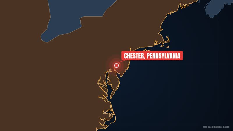
El Faro's story begins in 1975. She was built in Chester, Pennsylvania, by Sun Shipbuilding and Drydock under the name Puerto Rico. She was a roll-on/roll-off and lift-on/lift-off cargo ship crewed by U.S. merchant mariners. Navieras de Puerto Rico operated her for fifteen years. In 1991 Saltchuk Resources, the parent company of TOTE Maritime, bought her and renamed her Northern Lights.
In 1992 she was converted at Atlantic Marine Shipyard in Mobile, Alabama, where a new 90-foot mid-body, roughly 27 meters, was added. Between 2005 and 2006 the same shipyard carried out a second modification, this time providing for lift-on/lift-off cranes. The work included 4,875 long tons of fixed ballast, and the ship's load line was raised by about 2 feet so she could carry more cargo. One important point, however: a required damage stability assessment was not carried out. We will return to this later.
In February 2003, just before the American attack on Iraq, the Military Sealift Command chartered the ship as part of Operation Iraqi Freedom. She carried Marines and military equipment from San Diego to Kuwait. On 19 March she came under missile fire in the Persian Gulf. Nearby explosions shook the ship, but there was no damage and no one was hurt. By October 2005 she had made 25 voyages and 49 port calls, delivering 12,200 pieces of military equipment weighing 81,000 short tons. Air Force General Norton A. Schwartz praised the TOTE team for showing the U.S. flag industry at its best.
Military service ended in 2006. TOTE handed the ship to its subsidiary Sea Star Lines, and she was renamed El Faro. She returned to her old route and became a lifeline between the American mainland and Puerto Rico.
On paper, her record was sound. The Coast Guard inspected her in March and June 2014, and American Bureau of Shipping surveys were completed in February 2015. The NTSB found that safety drills were held every week and that the ship met stability criteria when she left Jacksonville.
Former crew members told a different story. They called her a rust bucket that should never have been on the water. They described drainage problems and leaks in a galley compartment, and said there were holes in the decks as recently as two months before she sank. After the accident, the Coast Guard examined her sister ship, El Yunque. Its cargo ventilation system was in poor condition, and the Coast Guard said this could allow intermittent flooding in seas of 25 to 30 feet. Was the same true of El Faro?
Chapter 3Leaving Jacksonville
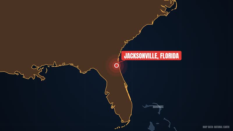
At 8:10 p.m. on 29 September 2015, El Faro left the port of Jacksonville, Florida, bound for San Juan, Puerto Rico. She carried 391 shipping containers and about 294 trailers and cars, all destined for Puerto Rico. The crew numbered 33: 28 Americans and 5 Poles. Each had a life, a family and a story. The ship was 40 years old and 790 feet long. How small even a ship that large can be against a hurricane was something time was about to show.
Captain Michael Davidson was in command. Coast Guard Capt. Jason Neubauer later said Davidson was ultimately responsible for the ship, the crew and safe navigation. Davidson planned to take El Faro's normal direct route. He hoped the ship would pass south of Hurricane Joaquin. At that point Joaquin was only a tropical storm, but forecasts indicated that its winds could come close to the ship's normal route.
Joaquin was then several hundred miles east of El Faro. Forecasters at the NHC spoke of great uncertainty about its track and intensity. Some weather models suggested the storm could approach the American East Coast, but a ridge was expected to turn it suddenly southwest toward the Bahamas. National Hurricane Center meteorologists expected it to become a hurricane by the morning of 1 October and move southwest toward the Bahamas. Under the voyage plan, the ship would pass within 175 nautical miles of the storm, where waves above 10 feet were possible.
So should Davidson never have sailed? According to the investigation, the decision to leave Jacksonville was reasonable given the options available. But the NTSB also said that later Davidson did not take enough action to avoid the hurricane. We will see how.
Former crew members later expressed astonishment that the ship sailed when a large storm was near her planned track. Coast Guard investigators concluded that Davidson underestimated both the storm's strength and the ship's vulnerability. After this trip El Faro was to return to Tacoma to replace another vessel, so a full schedule lay ahead of her.
The cranes of Jacksonville fell behind, and El Faro entered the open Atlantic. Over the next two days Joaquin would change quickly. Ten hours after leaving Jacksonville, El Faro had already moved off her charted course, and less than twenty hours after that a satellite alert would come. Did the ship stay on the same route? And when the storm drew closer, who on the bridge spoke up? We will see in the next part.
Chapter 4A Storm Grows Closer
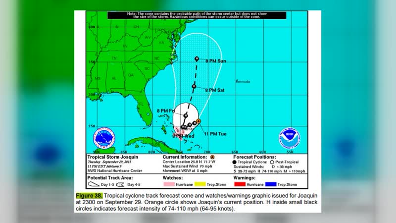
Joaquin's story began on 28 September. A non-tropical low southwest of Bermuda turned into a tropical depression, and on 29 September it was named Joaquin. It did not seem so dangerous at first. NHC meteorologists initially thought, based on computer models, that the system might die out within 96 hours. Then a mid-level ridge strengthened, and Joaquin's path suddenly turned southwest, toward the Bahamas. Sea temperatures were about 1.1 degrees Celsius above normal and wind shear was weakening. Both factors were giving the storm strength. On the morning of 30 September Joaquin became a hurricane, rapid intensification began, and a clear eye started forming at its center.
Now to El Faro's bridge. At 6:40 on the morning of 30 September, Davidson and the chief mate looked at updated weather data and altered course slightly south. It was a very small change. Davidson hoped the ship would pass south of the storm, but the storm's wind fields were forecast to lie close to the usual route. By plan, El Faro was to pass within 175 nautical miles of the storm, where waves above 10 feet were possible.
Joaquin kept moving southwest that day. By night it had reached Category 3, with maximum sustained winds of 100 knots. At 11:05 p.m. the third mate phoned Davidson to say Joaquin's maximum winds were now 100 mph, and that the storm was moving toward El Faro's planned track. A few minutes later, at 11:13, he called again, this time recommending a diversion to the south. In the dark of night, the alarm had been raised not once but twice.
Then, at about 1:20 a.m. on 1 October, second mate Danielle Randolph also phoned Davidson. She suggested changing course to go through the Crooked Island Passage. Randolph was clearly worried. She wrote in an email to friends and family: "There is a hurricane out here and we are heading straight into it."
By the morning of 1 October Joaquin was a Category 4. At about 12:00 UTC it passed over Samana Cay with 130 mph winds. Several members of the crew were feeling the danger. According to the NTSB, Davidson nonetheless did not take enough action to avoid the storm. The NTSB also said he relied on outdated weather information from the commercial Bon Voyage System, meaning he did not use the most recent information.
And El Faro was still heading toward this storm. The question was: when several officers were pointing out the danger, why was the decision not changed?
Chapter 5Twenty-Six Hours on the Recorder: The Final Morning
On 13 December 2016 the NTSB released a 500-page transcript. It recorded what was said on the ship's bridge during the last 26 hours. At 5:43 on the morning of 1 October, Davidson received a call about suspected flooding in No. 3 cargo hold. He sent the chief mate to investigate, and the crew began trying to understand and stop the flooding. Thirty minutes later the ship's steam propulsion plant shut down.
At 6:54 Davidson said by phone that a scuttle had been left open or had come open, and that a good deal of water had entered three hold. He said everyone was safe for now, they were not abandoning ship, and they would stay with the ship. There was no need yet to sound the general alarm. At 7:06 he spoke to the Qualified Individual. He said the hull had been breached, a scuttle had opened in the storm, and the main propulsion unit was not working. He added that there was a good deal of water in three hold, a very healthy list to port, and that engineers could not build lube oil pressure. He said the swell was from the northeast at 10 to 12 feet, with strong winds and very poor visibility. They would stay with the ship.
At 7:10 Davidson said the list was 10 to 15 degrees, though much of it was wind heel. He was about to make a distress call to the Coast Guard. He told the second mate to activate the Ship Security Alert System and the Global Maritime Distress and Safety System, and ordered the rest of the crew woken.
At 7:15 the chief mate returned to the bridge. He said, "Captain, I think the water level is rising." Davidson asked where the water was coming from. The chief mate said the chief engineer thought something had struck the fire main, and added that whatever he said was a guess. At 7:17 the chief engineer reported over the sound-powered phone that a bilge alarm was sounding in two alpha. The chief mate said cars were floating in No. 3 hold. According to the chief mate, the fire main was below the water level, which is why no damage was visible. Two minutes later Davidson told the chief engineer to close the fire pump suction isolation valve so there would be no direct connection to the sea.
At 7:24 Davidson said by phone, "We have reserve buoyancy and stability at this time." Immediately afterward he told the second mate to sound the general alarm. Then came the order to abandon ship. About a minute later a voice on the bridge said, "Bow is down, bow is down!" The front of the ship was going down. Davidson told the chief mate on the UHF radio: "Get into your rafts! Throw all your rafts into the water! Everybody get off! Get off the ship! Stay together!"
For the next few minutes Davidson tried to calm the frightened helmsman. "Work your way up here. You're okay. I'm not leavin' you, let's go!" The helmsman cried out: "I need a ladder! A line! I need someone to help me!" It is heartbreaking to hear, but it is on the recording. The VDR recording ends at 7:39. At that time Davidson and the helmsman were both on the bridge. The last words were: "It's time to come this way!"
Meanwhile, at about 7:30, the Coast Guard received a satellite notification that the ship had lost propulsion, had taken on water and had a 15-degree list. The message described the flooding as contained. The Coast Guard received only a single ping from the Emergency Position Indicating Radio Beacon, and attempts to make contact failed.
According to Marine Traffic, El Faro's last position at 4:01 was 24.2747°N 74.94522°W, and she was traveling south-southeast at 19 knots. According to another positioning database relayed by Reuters, at 7:56 the ship was at 23.52°N 74.02°W, about 35 nautical miles northeast of Crooked Island. That location was in Joaquin's eyewall, where winds above 80 knots were blowing. What would the searchers find?
Chapter 6Searching the Sea
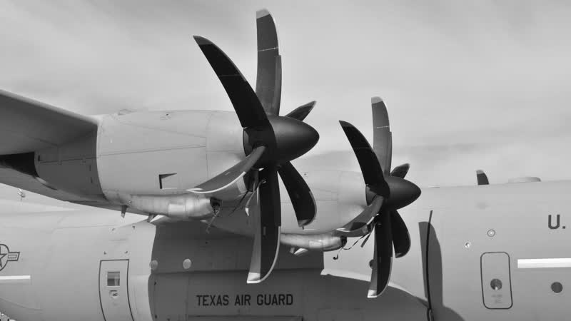
On 1 October a WC-130J Super Hercules from the U.S. Air Force Reserve's 53rd Weather Reconnaissance Squadron tried to find El Faro without success. On 2 October an HC-130H Hercules from Coast Guard Air Station Clearwater, Florida, began a formal search. USCGC Northland and an MH-60T Jayhawk joined the same day.
On 3 October aircraft were flying in severe hurricane conditions, with winds above 100 knots, waves up to 40 feet and visibility under 1 nautical mile. Even so, a helicopter crew recovered El Faro's life ring. Hope and dread ran side by side. On 4 October, as Joaquin moved away, the weather improved, with winds averaging 15 knots and unlimited visibility. One helicopter stayed in the air for 11 hours. On 4 October a second HC-130, USCGC Charles Sexton and USCGC Resolute also arrived. Earlier, on 3 October, a Navy P-8A Poseidon and three Crowley Maritime tugboats had come to help.
At 4:57 p.m. on 4 October, the P-8A Poseidon spotted an orange immersion suit about 40 nautical miles west-northwest of El Faro's last known position. About 90 minutes later the MH-60T found the suit. The rescue diver found a body inside, but it could not be identified. At that moment the crew was told that the P-8A had found another suit about 30 nautical miles away, with a possible survivor inside. The helicopter headed there. Before leaving, the diver had dropped a self-locating datum marker buoy on the first body. But on the return trip the buoy had failed, so the body could not be found.
On 5 October a deflated life raft and a heavily damaged, empty lifeboat were found. El Faro had two lifeboats, each with room for 43 people. The same day the ship was declared lost at sea. She was believed to be in 15,000 feet of water. It was now a search and recovery mission. On 6 October the Air Force and Air National Guard supplied three more HC-130P/J aircraft. In all, 183,000 square nautical miles were searched. Two debris fields were found. The first covered 260 square nautical miles, near the last position. The second covered 61 square nautical miles, 60 nautical miles to the northeast.
At sunset on 7 October the Coast Guard announced it was ending the search. None of the 33 crew members could be found alive. In the same storm, the 212-foot cargo vessel Minouche began to sink, but the Coast Guard rescued its 12 crew members from a life raft on the night of 1 October.
Joaquin also caused heavy destruction in the Bahamas. Between 1 and 3 October, Acklins, Crooked Island, Long Island, Rum Cay and San Salvador Island were badly damaged. About 7,000 people were directly affected, 836 homes were destroyed, and damage was estimated at US$120 million. The same storm took El Faro's 33 crew.
The search ended, but the story did not. Where was the ship? And did her recorder hold the voices of the final hours? We look at that next.
Chapter 7Finding the Wreck and the Black Box
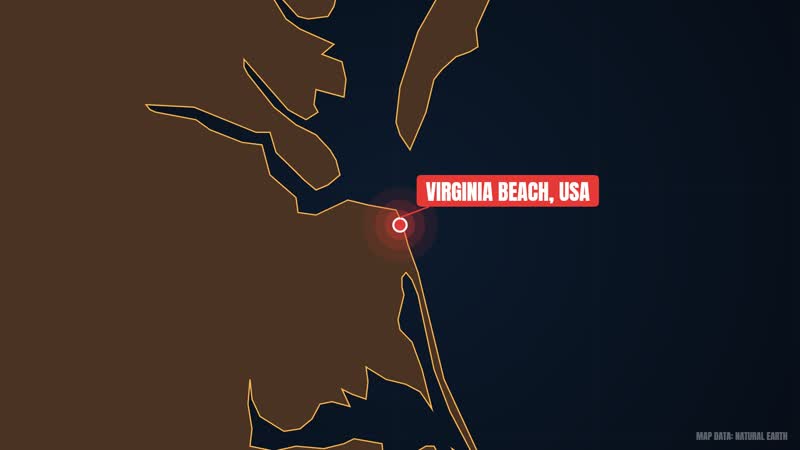
On 19 October the Navy ship USNS Apache left Virginia Beach. She carried a towed pinger locator, side-scan sonar and a remotely operated vehicle. Another source says Apache resumed the search on 23 October. The dates differ, but both sources agree on 31 October. On 31 October a large object appeared on sonar. The depth was about 15,400 feet, where pressure comes to roughly 6,688 pounds per square inch. The NTSB said the object resembled a 790-foot cargo ship, upright and in one piece.
The next day the Navy announced that submersible images had identified the wreck as El Faro. On 16 November the NTSB confirmed it. But one big gap remained: the recorder had not been found. On 3 January 2016 the NTSB opened its docket and released underwater images and video.
A second search began on 18 April 2016. This time RV Atlantis was used, a Navy-owned ship operated by mariners of the Woods Hole Oceanographic Institution. On 26 April the NTSB announced that the recorder had been found, 41 miles northeast of Acklins and Crooked Islands. But it was very close to the mast. Because of the mast and other obstructions, it was not possible to retrieve the recorder at that time. The team had to come back.
On 5 August 2016 USNS Apache returned to the same spot. Five days later, on 10 August, the recorder was retrieved. One source gives the date as 9 August. It was recovered from 15,250 feet, or 4,650 meters. One source says this is among the deepest VDR recoveries to date. Ten months after the accident, the recorder was handed over to the NTSB in Mayport, Florida. Investigators now had the ship's own voice.
The VDR is also called a ship's black box. Under the rules, it is mandatory on passenger ships and on other ships of 3,000 gross tonnage and above built after 2002. The unit can record position, speed, heading, radar, bridge audio, VHF radio and alarms. In other words, a ship's decisions and circumstances are preserved together.
El Faro's recorder held more than 26 hours of bridge audio and sensor data. From it investigators could rebuild the ship's final hours in detail. On 13 December 2016 the NTSB released the 500-page transcript, which included recordings from six microphones. According to the NTSB, the data shed light on navigation decisions, a lack of weather information and company safety management problems. So now the question was: who was to blame?
Chapter 8Who and What Sank El Faro?
Now comes the question asked after every accident: who sank El Faro? The answer lies in two major investigations. The Coast Guard's Marine Board of Investigation completed its report on 24 September 2017 and published it on 1 October. It ran to 199 pages. The investigation was led by Captain Jason Neubauer. Investigators placed almost all the blame on Davidson, who underestimated both the storm and the ship's vulnerability. Despite his crew's concerns, Davidson did not take enough action to avoid the storm. Had he survived, his license could have been revoked.
But the Coast Guard did not spare TOTE Maritime either. The company was accused of several violations relating to crew rest and working hours. There was no dedicated safety officer overseeing the ship. And the lifeboats were old open-air designs, of the kind found on old ships from the era of the Titanic.
Then, on 12 December 2017, the NTSB held a board meeting in Washington. Its 400-page report raised questions about Davidson, the company and the regulators alike. According to the NTSB, the first part of the probable cause was the captain's decisions: insufficient action to avoid the storm and failure to use the most current weather information. It also included the late decision to muster the crew. He had relied on outdated weather information from the Bon Voyage System. Ineffective bridge resource management was another cause, meaning the captain did not give full attention to his officers' suggestions. TOTE's oversight and safety system were also inadequate.
Now consider the technical chain. Flooding occurred in a cargo hold through an undetected open watertight scuttle and damaged seawater piping. Then the continuous list caused the main engine's lube oil pressure to drop and propulsion was lost. After that, downflooding into the cargo holds occurred through unsecured ventilation closures. The NTSB said there was no approved damage control plan. The loss of life also involved a lack of survival craft suitable for the conditions. The NTSB also criticized the Coast Guard's grandfathering policy, under which older ships were exempt from having closed lifeboats. El Faro's old lifeboats were not properly maintained, were not launched, and might not even have provided effective shelter.
Another aspect was the 2005-06 modification, in which 4,875 long tons of ballast were added but the required damage stability assessment was not done.
But the picture is not one-sided. The ship had passed two inspections in 2014 and ABS surveys in February 2015, and according to the NTSB the stability criteria were met at departure. The Coast Guard recommended fines of 5,350 dollars on TOTE for five code violations. According to one source, the company did not file any internal incident record.
Legal action followed. On 14 October 2015 the family of one crew member sued TOTE for 100 million dollars. The first suit alleged negligence. By 19 April 2016 TOTE Maritime had settled with 18 of the 33 families for more than 7 million dollars.
So was this only one captain's mistake? The Coast Guard mostly says yes, while the NTSB also listed weaknesses in the company and the system.
Chapter 9What Changed, and What We Still Ask
Congress passed the Hamm Alert Maritime Safety Act in 2019. The law is named after a person who lost his life in the El Faro accident. Under it, cargo ships will receive timely weather forecasts and hurricane alerts. Emergency gear will include location beacons, and there will be an anonymous reporting system for crew.
Memorials have also been built. There are two in Jacksonville and San Juan, and a memorial made by Jay Sawyer in Rockland, Maine. There is a plaque on the pier in Gdynia, Poland, because five crew members were Polish. Another memorial was dedicated in Dania Beach, Florida, on 29 September 2018.
El Faro's sister ships have also departed. El Morro was scrapped in 2012 and El Yunque in 2017, both after Coast Guard inspections. MV Isla Bella was chosen to take over El Faro's operations. But no new ship can replace those 33 people. And the storm's name? The World Meteorological Organization retired the name Joaquin in April 2016. In the 2021 season it was replaced by Julian.
Questions remain. Why did Davidson not heed his crew? The NTSB calls it ineffective bridge resource management, but we do not know his thinking. The lesson is simple: when the crew speaks of danger, it is essential to listen. Danielle Randolph had advised going through the Crooked Island Passage. Remembering the 33 is the way to do them justice. If you liked this story, please like the video and subscribe to the channel.
Shorts
"Bow is down!" El Faro's Last Minutes on the Bridge
Premieres:
"We're Not Abandoning Ship" El Faro's Final Morning
Premieres:
El Faro Found: A Giant Wreck 15,000 Feet Below the Sea
Premieres:
Sources
- SS El Faro — Wikipedia (CC BY-SA 4.0)
- Hurricane Joaquin — Wikipedia (CC BY-SA 4.0)
- Voyage data recorder — Wikipedia (CC BY-SA 4.0)
- TOTE Maritime — Wikipedia (CC BY-SA 4.0)
Photo credits
- TS Joaquin advisory 11 a.m.. EST 29 Sept, 2015 — National Weather Service Graphic, Public domain
- Model of the wreck of the El Faro (38972122842) — National Transportation Safety Board, Public domain
- Joaquin 2015-10-01 1145z — National Oceanic and Atmospheric Administration; provided via the United States , Public domain
- Illustration of Significant events between 420 a.m and the sinking of El Faro showing ship's heading and course — U.S. Coast Guard, Public domain
- El Faro Alternate, Normal and Accident Routes Jacksonville to San Juan Figure 5 from NTSB Report — U.S. Coast Guard Diagram, Public domain
- EL FARO VDR Photo (26569406162) — NTSBgov, Public domain
- CURV photo of the stern of El Faro 160103-N-ZZ999-550 — (U.S. Navy video frame grab/Released), Public domain
- Joaquin 2015 Bahamas path — KN2731, CC BY-SA 4.0
- Joaquin 2015-10-03 1437Z — National Oceanic and Atmospheric Administration; provided via the United States , Public domain
- Ship Voyage Data Recorder — Hervé Cozanet, CC BY-SA 3.0
- DM100 VDR G2 — MultiPazz!, CC BY-SA 4.0


Stock footage & photos
- By Bisan Subba on Pexels
- By Wolfgang Vrede on Pexels
- By Murry Lee on Pexels
- By Abdulmutalip BOZKUS on Pexels
- By Nabil Naidu on Pexels
- By Pixabay on Pexels
- By Tom Fisk on Pexels
- By Tom Fisk on Pexels
- By Toàn BDS on Pexels
- By Somogro Bangladesh on Pexels
- By sakibul Hasan on Pexels
- By Markus Winkler on Pexels
- By JANILSON PEREIRA TRARBACH on Pexels
- By Ozan Tabakoğlu on Pexels
- By Oleksiy Yeshtokyn,🌻🇺🇦🌻 on Pexels
- By K on Pexels
- By the Amritdev on Pexels
- By Henley Wang on Pexels
- By Mehmed Ali Bekman on Pexels
- By RDNE Stock project on Pexels
- By Cecilia Ravalli on Pexels
- By wowi allinsky on Pexels
- By Khusen Rustamov on Pexels
- By RDNE Stock project on Pexels
- By Wei86 Travel on Pexels
- By willy one on Pexels
- By Oleksiy Yeshtokyn,🌻🇺🇦🌻 on Pexels
- By Tom Fisk on Pexels
- By Luk Sauvage on Pexels
- By Vinay on Pexels
- By SpaceX on Pexels
- By Guy Kawasaki on Pexels
- By cottonbro studio on Pexels
- By Emir Anık on Pexels
- By RDNE Stock project on Pexels
- By Seven Seil on Pexels
- By Glenn Langhorst on Pexels
- By Fatih Turan on Pexels
- By Lucas Leonel Suárez on Pexels
- By Rafael Minguet Delgado on Pexels
- By Sajjad Naqvi on Pexels
- By Connor Scott McManus on Pexels
- By ΘSWΛLD on Pexels
- By Tom Fisk on Pexels
- By Zelch Csaba on Pexels
- By Simon R. Minshall on Pexels
- By Glenn Langhorst on Pexels
- By Samet Korkmaz on Pexels
- By Dương Nhân on Pexels
- By ROMAN ODINTSOV on Pexels
- By Rain Lü on Pexels
- By Andrew Patrick Photo on Pexels
- By K on Pexels
- By Erik Reemst on Pexels
- By Navdeep singh on Pexels
- By Ron Lach on Pexels
- By Fred dendoktoor on Pexels
- By Mario Krimer on Pexels
- By Joerg Mangelsen on Pexels
- By Kampus Production on Pexels
- By ömer faruk ermiş on Pexels
- By dabatepatvideos on Pexels
- By Mike Bird on Pexels
- By Long Bà Mùi on Pexels
- By Mytho Digital on Pexels
- By Wolfgang Weiser on Pexels
- By Maël BALLAND on Pexels
- By HONG SON on Pexels
- By Tony Rush on Pexels
- By William Jacobs on Pexels
- By Ron Lach on Pexels
- By Johannes Plenio on Pexels
- By Владимир Брызгин on Pexels
- By Francisco José Zangerolame on Pexels
- By Sinful on Pexels
- By CityXcape on Pexels
- By Phyllis Lilienthal on Pexels
- By Ronald Hayward on Pexels
- By Planespotter Geneva on Pexels
- By Tanhauser Vázquez R. on Pexels
- By Jonathan Ludford-Brooks on Pexels
- By Julia Barrantes on Pexels
- By İrem Dur on Pexels
- By nova drone on Pexels
- By Nikita Belokhonov on Pexels
- By Ali Soheil on Pexels
- By Igor Passchier on Pexels
- By Hussain Naushad on Pexels
- By Blaque X on Pexels
- By Alexander Popadin on Pexels
- By JUN HO LEE on Pexels
- By Matteo Parisi on Pexels
- By Kindel Media on Pexels
- By cottonbro studio on Pexels
- By cottonbro studio on Pexels
- By Kindel Media on Pexels
- By Arian Fernandez on Pexels
- By Иван Лемехов on Pexels
- By willy one on Pexels
- By H Clicks on Pexels
- By Alexander Zvir on Pexels
- By https://kaboompics.com/ on Pexels
- By Kampus Production on Pexels
- By Traveling on the Go on Pexels
- By Amar Preciado on Pexels
- By Eric Seddon on Pexels
- By Alin Buda on Pexels
- By Oleksiy Yeshtokyn,🌻🇺🇦🌻 on Pexels
- By Andreas Hoffmann on Pexels
- By Julio Agreda on Pexels
- By Mikhail Nilov on Pexels
- By In Old News LLC on Pexels
- By Mendez on Pexels
- By Kaybee Photography on Pexels
- By id23 on Pexels
- By cottonbro studio on Pexels
- By Mo Eid on Pexels
- By Glenn Langhorst on Pexels
- By Kaybee Photography on Pexels
- By Postcard Pictures on Pexels
- By Marianna Sigov on Pexels
This documentary is based on the sources above and was fact-checked before publishing. The narration voice, animated host and illustrations are AI-generated. Spotted a mistake? Tell us in the YouTube comments.